
Recommended
More Related Content
Viewers also liked
Viewers also liked (19)
Recently uploaded
Recently uploaded (20)
Big Wave Project FEIR: Planning Commission Hearing Nov 17 2010
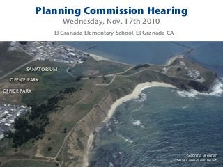
- 1. Planning Commission Hearing Wednesday, Nov. 17th 2010 El Granada Elementary School, El Granada CA SANATORIUM OFFICE PARK OFFICE PARK Sabrina Brennan Seal Cove-Moss Beach
- 5. Is the Big Wave Project prepared for an emergency? SANATORIUM OFFICE PARK Rancho Corral de Tierra POST Pillar Point Bluff FMR HMB Airport POST POST POST
- 6. “The proximity of the project to the partially enclosed Pillar Point Harbor and the potential for tsunami events could expose people to inundation by seiche, which represents a potentially significant impact.” Big Wave Project DEIR IV.H Hydrology & Water Quality Page IV.H-61
- 7. 2007 Grand Jury Report Tsunami Alert and Evacuation On the San Mateo County Coast SANATORIUM BIG WAVE TSUNAMI INUNDATION ZONE Half Moon Bay, CA
- 8. A seiche (pronounced /ˈseɪʃ/ "saysh") is a standing wave in an enclosed or partially enclosed body of water.
- 9. The tsunami that hit Hawaii in 1946 had a fifteen- minute interval between wave fronts. The natural resonant period of Hilo Bay is about thirty minutes. That meant that every second wave was in phase with the motion of Hilo Bay, creating a seiche in the bay. As a result, Hilo suffered worse damage than any other place in Hawaii, with the tsunami/seiche reaching a height of 26 feet along the Hilo Bayfront, killing 96 people in the city alone. Seiche waves may continue for several days after a tsunami. Hilo Bay Seiche April 1st 1946
- 10. In 1946 a Tsunami hit Princeton By-The-Sea April 1, 1946 Tsunami DebrisWater Resources Center Archives: Robert L. Wiegel
- 11. Princeton By-The-Sea April 1, 1946 Water Resources Center Archives: Robert L. Wiegel
- 12. Romeo Pier: April 1, 1946 Water Resources Center Archives: Robert L. Wiegel
- 13. Romeo Pier: April 2, 1946 (day after the Tsunami) Water Resources Center Archives: Robert L. Wiegel
- 14. Tsunami water level April 1, 1946 Princeton By-The-Sea Water Resources Center Archives: Robert L. Wiegel
- 15. Tsunami water level April 2, 1946 (day after the Tsunami) Water Resources Center Archives: Robert L. Wiegel
- 16. “Structures should either be placed at elevations above those likely to be adversely affected during a tsunami or seiche event or be designed to allow swift water to flow around, through, or underneath without causing collapse.” Big Wave Project DEIR IV.H Hydrology & Water Quality Page IV.H-61
- 17. ABAG tsunami maps show that the project would place residential and commercial structures within a mapped tsunami zone.
- 18. Would you want to be trapped with swirling water and debris all around you? Would you want to desperately try and escape a natural disaster with traffic from the office park choking your exit? How do special needs people get the necessary evacuation help needed? Emergency Evacuation
- 19. The San Gregorio fault, just off the San Mateo County Coast, has the potential of causing a tsunami with essentially no warning time. The San Mateo County Office of Emergency Services (OES) advises that members of the public who are in low- lying areas immediately head for high ground when an earthquake occurs. Grand Jury Report: 2007 Tsunami Alert and Evacuation San Mateo County Coast Grand Jury Report
- 20. Princeton, Pillar Ridge & Seal Cove only have ONE Tsunami Evacuation Exit
- 21. Pi llar Po in t Marsh Jame s V. F i tzg e ral d Mar ine Re se r ve Critical Coastal Areas Pilot Project San Francisco Esturay Institute and the Association of Bay Area Governments, Consultants For more information, please contact Eric Zhang, Staff San Francisco Estuary Institute 7770 Pardee Lane, 2nd Floor Oakland, CA 94621 Kathleen Van Velsor, Staff Legen d Tsunami Evacuation Area Urban Footprint BIG WAVE
- 22. Princeton Traffic Bottlenecks BIG WAVE BIG WAVE Tsunami Evacuation Exit Emergency Evacuation Route Cypress Ave & Highway 1 Traffic Bottleneck
- 23. Earthquake and Tsunami Evacuation ALL TRAFFIC in PRINCETON, PILLAR RIDGE and SEAL COVE MUST USE CYPRESS AVE as the SOLE EVACUATION ROUTE ONTO HIGHWAY 1
- 24. Cypress Ave and Highway 1 is a Traffic Bottleneck How will residents, visitors and employees evacuate Princeton, Pillar Ridge, Seal Cove, the proposed Big Wave office park and sanitarium in the event of an earthquake or tsunami emergency? How will the current emergency evacuation route, ONE exit onto Highway 1 and NO traffic light at Cypress and Highway 1 be adequate in the event of an earthquake or tsunami emergency?
- 25. Emergency Evacuation Route Cypress Ave and Highway 1 A traffic signal is currently needed at this intersection.
- 26. Emergency Evacuation Route Cypress Ave and Highway 1 A traffic signal is currently needed at this intersection.
- 27. Emergency Evacuation Route Cypress Ave and Highway 1 A traffic signal is currently needed at this intersection.
- 28. BIG WAVE BIG WAVE BIG WAVE Princeton Traffic Bottlenecks Princeton Traffic Must Use Cypress Ave in Seal Cove as the Earthquake and Tsunami Emergency Evacuation Route
- 29. Princeton Traffic Bottlenecks Prospect at Broadway Capistrano Rd
- 30. James Fitzgerald Marine Reserve Critical Coastal Area State of California Area of Special Biological Significance (ASBS) part of the federally protected Monterey Bay National Marine Sanctuary
- 31. PACIFIC O C E A N S A N M A T E O a` a` a`a` a` a` a` a`a` a` a` a` a` a` a`a` a` a` a` a` a` a` a` a` a` a` a` a` a` a`a`a` a`a` a` a` a` a`a` a` a` a` a` a`a` a` a` a`a` a` a`a` a`a`a` a` a`a` a`a` a`a` a`a` a` a`a`a`a` a`a` a`a` a`a` a`a` a` a` a` a` a` a` a` a` a` a`a` a` a`a` a`a` a` a` a` a`a` a`a` a` a`a` a` a` a` a` a` a`a` a`a` a` a`a` a` a` a`a` a`a` a`a` a`a` a` a` a` (!! po po po !! !! !! !! !! !! !! !! !! !! !! !! !! !! !! !! !! !! !! !! !! !!!! !! !! !! !! !! !!!!!! !! !! !! !! !! !!!! !! !! !!!! !! !! !! !! !!!! !! !!!! !! !! !! !!!! !! !! !! !! !! !! !! !! !! !!!! !!!! !!!! !!!! !! !! !! !! !! !! !! !!!! !! !! !! !! !! !!!! !! !! !! !! !! !!!!!! !!!! !! !!!! !! !! !! !! !!!! !!!! !!!! !! !! !! !! !! !! !! !! !! !!!! !! !! !!!! !!!!!! !!!! !! !! !! !! !! !! !! !! !! !! !! !! !! !! !! !!!! !!!! !! !! !! !! !! !! !! !! !!!! !! !! !!!!!! !! !! !! !! !! !! !! !! !! !! !! !!!! !! !! !!!! !! !! !! !! !! !! !!!! !! !! !! !!!! !! !! !! !! !! !! !! !! !! !! !! !! !! !!!! !! !! !!!! !! !!!! !! !! !.!. !. !. !. !. !. !. !. !. !. !. !. !. !. !. !. !. !. !. Jam e s V.Fitzgerald M a rine Res e r v e Pillar Point Vallejo Beach Point Montara Mon tara Beach Miramar Beach Wahleman Harbor El Granada Beach H alf M oon Bay A irport Pillar Point Harbor Deer Creek Study Area Option Pillar Point Airforce Facility D eer C reek Sa n Vi cente Cree k LocksCreek D enn iston Cre e k D enni ston Creek ArroyoDeEnMedio LocksCreek FrenchmansCreek Mon tar a Creek Kanoff C reek D affo d il Creek Dean Creek Montara El Granada Moss Beach Half Moon Bay Rancho Co rral de Tierra Wicklow Pi llar Point Bluff Mont ara Stat e Beach SM Count y Wat er Dist rict El Gra nada Pa rk "Quarry " Po int Mont ara Lig ht House Rancho Co rral de Tierra San Fra nci sco Wat ershe d Lands Pillar Point Marsh ==1 DRAFT - FOR PLANNING PURPOSES S A N M A T E O C O U N T Y Yolo Sonoma Napa Solano Santa Clara Marin San Joaquin Alameda Sacramento Lake Contra Costa Stanislaus Placer Santa Cruz Sutter Mendocino San Mateo San Francisco Critical Coastal Area Boundary including ASBS BIG WAVE San Francisco Estuary Institute www.sfei.org
- 32. OFFICE PARK Fitzgerald Marine Reserve Pillar Point Wetlands
- 33. Pillar Point Wetlands Area of Special Biological Significance (ASBS) and part of the federally protected Monterey Bay National Marine Sanctuary Fitzgerald Marine Reserve
- 34. Denniston Creek Watershed San Vicente Creek Watershed Montara Creek Watershed Pillar Point Marsh Watershed Martini Creek Watershed San Agustine Creek Watershed Kanoff Creek Watershed Daffodil Creek Watershed Deer Creek Watershed Dean Creek* Watershed Seal Cove Watershed Moss Beach Watershed Montara Urban Watershed Princeton Watershed Harbor Watershed Montara Beach Watershed 0 0.3 0.6 0.90.15 Miles - Fitzgerald Marine Reserve CCA Natural and Artificial Hydrology 0.5 Miles F Legend Enclosed pipeline > 24 " Natural channels and earthen ditches CCA Boundary Subwatersheds Wetland and Riparian Areas CCA Boundary including ASBS www.sfei.org
- 35. Denniston Creek Watershed Pillar Point Marsh Watershed San Agustine Creek Watershed Deer Creek Watershed d ch ed Princeton Watershed Harbor Watershed 0.6 0.9 Miles -5 Miles F Legend Enclosed pipeline > 24 " Natural channels and earthen d CCA Boundary Subwatersheds Wetland and Riparian Areas CCA Boundary including ASBS BIG WAVE Pillar Point Marsh Watershed the San Francisco Estuary Institute www.sfei.org
- 36. AirportStreet Riparian Wetland/ Drainage Channel Active Agriculture Seasonal Wet Meadow Riparian Wetland Riparian Wetland Pillar Point Marsh Freshwater Marsh Active Agriculture 0 400200 300100 Legend Project Site Wetland Boundary BIG WAVE PROJECT SITE Seasonal Creek Pillar Point Marsh Riparian Wetland
- 37. Seasonal Creek
- 38. Seasonal Creek
- 39. Thank You Sabrina Brennan Seal Cove-Moss Beach