SlideShare a Scribd company logo
1 of 1
Download to read offline
Semantische Harmonisierung der amtlichen
Geobasisdaten ATKIS (3A) und ZABAGED
für den Freistaat Sachsen und die Tschechische Republik
C. Gedrange, S. Röhnert, M. Neubert


Hintergrund und Zielstellung                                                                                                                                                         Ergebnisse
Grenzüberschreitende Planung und Steuerung benötigen homogene grenzüber-                                                                                                             Bilinguale Objektartenkataloge
schreitende Datengrundlagen. Amtliche Geobasisdaten bieten hierfür die beste
Grundlage, beziehen sich jedoch nur auf das jeweilige Staatsgebiet. Allerdings                                                                                                           Semantisch korrekte Übersetzung aller Begriffe
weisen sie zahlreiche Unterschiede auf hinsichtlich:                                                                                                                                     und Definitionen in ATKIS und ZABAGED
                                                                                                                                                                                         Erstellung bilingualer Kataloge
      Metadaten                                                                                                                                                                          Bereitstellung als Datenbank mit allen Objektart-
      Datenmodelle                                                                                                        CZ                                                             Attributwert-Kombinationen in beiden Sprachen
      Klassifikationsschema
      Sprache/Terminologie
                                                                                                           DE
      semantische Bedeutung
      Referenzsysteme                                          ATKIS ®                                                                                           ZABAGED ®

      (Grenz-)Geometrie                                       Ausgangslage: Geobasisdaten vor der Harmonisierung


Die semantische Harmonisierung ist Voraussetzung für die Bereitstellung grenz-
überschreitend interoperabler und einheitlich interpretierbarer Daten.

  Geometrische Homogenisierung
     Integration einer einheitlichen Grenzgeometrie                                                                                                                                      Auszug Datenbank Bilingualer Objektartenkatalog ATKIS
     Einheitliches Koordinatenreferenzsystem
     Geometrische Verknüpfung
     grenzüberschreitender Objekte       Semantische Harmonisierung                                                                                                                  Zuordnungsfunktionen und -kategorien
                                            Bilinguale Objektartenkataloge
                                            Zuordnungsfunktionen                                                                                                                         Zuordnung auf Ebene der Objektart-Attributwert-
                                            Zuordnungskategorien zur semantischen                                                                                                        Kombination
                                            Vergleichbarkeit der Datenmodelle                                                                                                            Für beide Zuordnungsrichtungen
                                                                                                                                                                                         1100 Kombinationen für ATKIS
Methodik                                                                                                                                                                                 310 Kombinationen für ZABAGED
                                                                                                                                                                                         Kategorien zur Beurteilung der Zuordnungsgüte
      Integration durch Alignment                                                                                                                      Interoperable
                                                                                                                                                       Datenmodelle                       Kategorie Qualität           Beschreibung                                                         ATKIS
                                                                                                                                                                                             A      Eineindeutig       Ein Objekt aus Modell A lässt sich genau einem Objekt               Wald
                                                                                                                                                               Integration der                      A=Z                aus Modell Z zuordnen und umgekehrt.
                                                                                                                                                                Datenmodelle                 B      Eindeutig:         Ein Objekt des Modells A enthält ein Objekt des Modells Z           Attribut: Vegetationsmerkmal (VEG)
                                                                                                                                                                                                    Z ist Teil von A   und ggf. weitere Objekte oder Inhalte.
                                                                                                                                                                                                                                                                                                                Laub- und
                                                                                                                                                                                                                       Teile der Objekte überschneiden sich, aber jedes enthält            Nadelholz                                 Laubholz
                                                                                                                                                                                             C      Schnittmenge                                                                                                Nadelholz
                                                                                                                               Zuordnungs-                                                                             weitere Objekte oder Inhalte.
                                                                                                                              funktionen und
                                                                                                                                                                                             D      Eindeutig:         Ein Objekt des Modells Z enthält ein Objekt des Modells A                B                    D           D          D
          Ursprüngliche                                                                                        Erstellung von -kategorien                                                           A ist Teil von Z   und ggf. weitere Objekte oder Inhalte.
          Datenmodelle                                                                                        Transformations-
                                                                                                                                                                                             E      Teilmenge,         Objekte werden geführt, aber nicht näher spezifiziert. Sie
                                                                                                                   regeln                                                                           übergeordnet       sind semantisch übergeordnet.                                       ZABAGED                               ZABAGED

                                                                                                                                                                                             F      Ableitung          Objekte werden nicht spezifiziert geführt, lassen sich aber         Waldboden mit                         Waldboden mit
                                                                                                                                                                                                                       aus umgebenden oder enthaltenen Objekten ableiten.                  Latschenkiefern                       Baumbestand
                                                                                                   Homogenität
                                                                          Vergleich der                                                                                                                                Keine passenden Zuordnungen möglich.
                                                                                                   Heterogenität                                                                             G      keine
                                                                           Konzepte                                                                                                                 Zuordnung                                                                             Beispiel Mehrfachzuordnung
                                        Semantische                                                                                                                                      Zuordnungskategorien zur Bestimmung der Zuordnungsgüte
                                          Analyse                                                                                                                                                       (A=ATKIS, Z=ZABAGED)
                                                         Semantische
          Übersetzung                                     Konzepte                                                                                                                                                                                                                   ATKIS nach ZABAGED          ZABAGED nach ATKIS
                                                                                                                                                                                                                                                                                     60
                              Bilinguale                                                                                                                                                                                                                                             50
                          Objektartenkataloge                                                                                                                                                                                                                                        40
                                                                                               Vorgehensweise bei der semantischen Harmonisierung
                                                                                                                                                                                     Zuordnungsergebnisse                                                                            30
                                                                                                                                                                                                                                                                                     20
                                                                                                                                                                                                                                                                                     10

                                                                                                                                                                                         Heterogenitäten führen zu keiner Zuordnung,                                                  0


Datenmodelle                                                                                                                                                                             Teil- oder Mehrfachzuordnungen
                                                                                                                                                                                                                                                                                           A        B       C        D       E         F

                                                                                                                                                                                                                                                                                     Anteile der vergebenen Zuordnungskategorien für beide
                                                                                                                                                                                                                                                                                     Zuordnungsrichtungen
                                                                                                                                                                                         ATKIS nach ZABAGED: 30% zuordenbar                                                          ATKIS nach ZABAGED          ZABAGED nach ATKIS
Die Datenhomogenisierung erfolgt anhand der amtlichen Geobasisdaten:                                                                                                                     ZABAGED nach ATKIS: 70% zuordenbar                                                          90

    ATKIS® Basis-DLM im 3A-Modell (Amtlich Topographisch-Kartographisches                                                                                                                Eineindeutige Zuordnung: 20%                                                                80
                                                                                                                                                                                                                                                                                     70

    Informationssystem, Digitales Basis-Landschaftsmodell) sowie                                                                                                                         Mehrfachzuordnungen: 20-35%                                                                 60
                                                                                                                                                                                                                                                                                     50

    ZABAGED ® Modell 2010 (Základní báze geografických dat)                                                                                                                                                                                                                          40
                                                                                                                                                                                                                                                                                     30
                                                                                                                                                                                                                                                                                     20
                                                                                                                                                                                                                                                                                     10

ATKIS                             ZABAGED                                                            ATKIS                                                 ZABAGED                                                                                                                    0


                                                                                                                                                                                     Kooperationen
                                                                                                                                                                                                                                                                                            1           2        3       4            5
                                                                                                  Basisschema                                              Festpunkte
   Objektbereich                       Objektbereich                                                Gebäude
                                                                                                                                                                                                                                                                                     Anteile Einfach- und Mehrfachzuordnung an zugeordneten
                                                                                                                                                                                                                                                                                     Kombinationen für beide Zuordnungsrichtungen
                                                                                                                                                                Siedlung
                                                                                                        Siedlung
                                                                                  Tatsächliche


                                                                                                                                Tatsächliche Nutzung
                                                                                    Nutzung


     Objektartengruppe                                                                                  Verkehr
                                                                                                       Vegetation
                                                                                                                                                             Stromerzeugung
                                                                                                                                                                                     Die Durchführung des Projektes erfolgt in enger Zusammen-
                                                                                                       Gewässer                                                  Verkehr             arbeit mit den Landesvermessungsbehörden beider Länder:
              Objektart                          Objektart                                              Siedlung
                                                                                                                                                                                         Staatsbetrieb Geobasisinformation und Vermessung Sachsen (GeoSN)
                                                                                    Bauwerke


                                                                                                        Verkehr                                                Vegetation

                   Attributart
                                                                                                       Vegetation                                                                        Landesvermessungsamt Tschechische Republik (Zeměměřický úřad, ZÚ)
                                                       Attributart                                                                                              Gewässer
                                                                                                       Gewässer
                                                                                                     Relief                                                   Relief
                        Attributwert                       Attributwert                                 Kataloge                                         Gebietseinheiten
                                                                                                                                                                                     Die Integration der Projektergebnisse in die amtlichen Geobasisdaten, in die landes-
                                                                                                                                                                                     spezifischen internetbasierten Geoportale sowie die Nutzung in anderen grenzüber-
                                                                                  einheiten
                                                                                  Gebiets-


                                                                                                   Öffentlich-rechtlich
                                                                                                     Geographisch
                                                                                                      Administrativ
                                                                                                                               Thematische Gliederung                                schreitenden Projekten wie CROSS-DATA tragen im Sinne von INSPIRE zu einer
Struktur der ATKIS- und ZABAGED-Kataloge                                                                                       der Objektbereiche
                                                                                                                                                                                     besseren Zugänglichkeit und Interoperabilität von umweltrelevanten Geodaten bei.

Semantische Unterschiede bestehen vor allem in der Verwendung unterschiedlicher
   Schemata                     Sprachen
   Detailierungsgrade           Begriffe
   Klassifikationen             Beschreibungen


 Leibniz-Institut
Leibniz Institute                                            Direktor: Prof. Dr. Dr. h.c. Bernhard Müller
                                                             Director: Prof. Dr. Dr. h.c. Bernhard Müller

                                                                                                                                                                                                                                                                              www.ioer.de
 für ökologische Raumentwicklung e. V.                       Posterinhalt und Gestaltung: Claudia
                                                                                                                                                                                 www.geodat.ioer.info
of Ecological and Regional Development
Weberplatz 1 1
 Weberplatz
 01217 Dresden
01217 Dresden
                                                             Gedrange, Sylvia Röhnert, Marco Neubert
                                                             November 2010
                                                                                                                                                                                                                                                                              www.ioer.de
Germany

More Related Content

More from IGN Vorstand

GI2016 ppt hoffmann address+history from_gi2000_to_gi2016
GI2016 ppt hoffmann address+history from_gi2000_to_gi2016GI2016 ppt hoffmann address+history from_gi2000_to_gi2016
GI2016 ppt hoffmann address+history from_gi2000_to_gi2016IGN Vorstand
 
GI2016 ppt böhm saxonian_gdi_1_grenze_hi_hedo
GI2016 ppt böhm saxonian_gdi_1_grenze_hi_hedoGI2016 ppt böhm saxonian_gdi_1_grenze_hi_hedo
GI2016 ppt böhm saxonian_gdi_1_grenze_hi_hedoIGN Vorstand
 
GI2016 ppt böhm saxonian_gdi_2_eine_bwk_entsteht
GI2016 ppt böhm saxonian_gdi_2_eine_bwk_entstehtGI2016 ppt böhm saxonian_gdi_2_eine_bwk_entsteht
GI2016 ppt böhm saxonian_gdi_2_eine_bwk_entstehtIGN Vorstand
 
GI2016 ppt böhm saxonian_gdi_3_vimage
GI2016 ppt böhm saxonian_gdi_3_vimageGI2016 ppt böhm saxonian_gdi_3_vimage
GI2016 ppt böhm saxonian_gdi_3_vimageIGN Vorstand
 
GI2016 ppt charvat senslog api as tools for collection of big vgi data
GI2016 ppt charvat senslog api as tools for collection of big vgi dataGI2016 ppt charvat senslog api as tools for collection of big vgi data
GI2016 ppt charvat senslog api as tools for collection of big vgi dataIGN Vorstand
 
GI2016 ppt charvat workshop geoss & conference inspire2016
GI2016 ppt charvat workshop geoss & conference inspire2016GI2016 ppt charvat workshop geoss & conference inspire2016
GI2016 ppt charvat workshop geoss & conference inspire2016IGN Vorstand
 
GI2016 ppt mayer copernicus_dresden
GI2016 ppt mayer copernicus_dresdenGI2016 ppt mayer copernicus_dresden
GI2016 ppt mayer copernicus_dresdenIGN Vorstand
 
GI2016 ppt schiller dbd-bauprofessor & zuse-dualsemantik
GI2016 ppt schiller dbd-bauprofessor & zuse-dualsemantikGI2016 ppt schiller dbd-bauprofessor & zuse-dualsemantik
GI2016 ppt schiller dbd-bauprofessor & zuse-dualsemantikIGN Vorstand
 
GI2016 ppt schiller kostenkalkül
GI2016 ppt schiller kostenkalkülGI2016 ppt schiller kostenkalkül
GI2016 ppt schiller kostenkalkülIGN Vorstand
 
GI2016 ppt shi (automatic interaction and seamless integration of big data hu...
GI2016 ppt shi (automatic interaction and seamless integration of big data hu...GI2016 ppt shi (automatic interaction and seamless integration of big data hu...
GI2016 ppt shi (automatic interaction and seamless integration of big data hu...IGN Vorstand
 
GI2016 ppt shi (big data analytics on the internet)
GI2016 ppt shi (big data analytics on the internet)GI2016 ppt shi (big data analytics on the internet)
GI2016 ppt shi (big data analytics on the internet)IGN Vorstand
 
GI2016 ppt shi (cartography and communication)
GI2016 ppt shi (cartography and communication)GI2016 ppt shi (cartography and communication)
GI2016 ppt shi (cartography and communication)IGN Vorstand
 
GI2016 Open Call for Presentations
GI2016 Open Call for PresentationsGI2016 Open Call for Presentations
GI2016 Open Call for PresentationsIGN Vorstand
 
GI2015 ppt hoffmann_address_intro
GI2015 ppt hoffmann_address_introGI2015 ppt hoffmann_address_intro
GI2015 ppt hoffmann_address_introIGN Vorstand
 
GI2015 programme+proceedings
GI2015 programme+proceedingsGI2015 programme+proceedings
GI2015 programme+proceedingsIGN Vorstand
 
CoO + GI2015 ppt_charvat ict for a sustainable agriculture – public support n...
CoO + GI2015 ppt_charvat ict for a sustainable agriculture – public support n...CoO + GI2015 ppt_charvat ict for a sustainable agriculture – public support n...
CoO + GI2015 ppt_charvat ict for a sustainable agriculture – public support n...IGN Vorstand
 
CoO + GI2015 ppt_mayer ict for a sustainable agriculture - status and missing
CoO + GI2015 ppt_mayer ict for a sustainable agriculture - status and missingCoO + GI2015 ppt_mayer ict for a sustainable agriculture - status and missing
CoO + GI2015 ppt_mayer ict for a sustainable agriculture - status and missingIGN Vorstand
 
GI2015 ppt karas dresden j.karas
GI2015 ppt karas dresden j.karasGI2015 ppt karas dresden j.karas
GI2015 ppt karas dresden j.karasIGN Vorstand
 
GI2015 ppt hladikova copernicus_agriculture_forestry_lh
GI2015 ppt hladikova copernicus_agriculture_forestry_lhGI2015 ppt hladikova copernicus_agriculture_forestry_lh
GI2015 ppt hladikova copernicus_agriculture_forestry_lhIGN Vorstand
 
GI2015 ppt fiore eurisy_presentation
GI2015 ppt fiore eurisy_presentationGI2015 ppt fiore eurisy_presentation
GI2015 ppt fiore eurisy_presentationIGN Vorstand
 

More from IGN Vorstand (20)

GI2016 ppt hoffmann address+history from_gi2000_to_gi2016
GI2016 ppt hoffmann address+history from_gi2000_to_gi2016GI2016 ppt hoffmann address+history from_gi2000_to_gi2016
GI2016 ppt hoffmann address+history from_gi2000_to_gi2016
 
GI2016 ppt böhm saxonian_gdi_1_grenze_hi_hedo
GI2016 ppt böhm saxonian_gdi_1_grenze_hi_hedoGI2016 ppt böhm saxonian_gdi_1_grenze_hi_hedo
GI2016 ppt böhm saxonian_gdi_1_grenze_hi_hedo
 
GI2016 ppt böhm saxonian_gdi_2_eine_bwk_entsteht
GI2016 ppt böhm saxonian_gdi_2_eine_bwk_entstehtGI2016 ppt böhm saxonian_gdi_2_eine_bwk_entsteht
GI2016 ppt böhm saxonian_gdi_2_eine_bwk_entsteht
 
GI2016 ppt böhm saxonian_gdi_3_vimage
GI2016 ppt böhm saxonian_gdi_3_vimageGI2016 ppt böhm saxonian_gdi_3_vimage
GI2016 ppt böhm saxonian_gdi_3_vimage
 
GI2016 ppt charvat senslog api as tools for collection of big vgi data
GI2016 ppt charvat senslog api as tools for collection of big vgi dataGI2016 ppt charvat senslog api as tools for collection of big vgi data
GI2016 ppt charvat senslog api as tools for collection of big vgi data
 
GI2016 ppt charvat workshop geoss & conference inspire2016
GI2016 ppt charvat workshop geoss & conference inspire2016GI2016 ppt charvat workshop geoss & conference inspire2016
GI2016 ppt charvat workshop geoss & conference inspire2016
 
GI2016 ppt mayer copernicus_dresden
GI2016 ppt mayer copernicus_dresdenGI2016 ppt mayer copernicus_dresden
GI2016 ppt mayer copernicus_dresden
 
GI2016 ppt schiller dbd-bauprofessor & zuse-dualsemantik
GI2016 ppt schiller dbd-bauprofessor & zuse-dualsemantikGI2016 ppt schiller dbd-bauprofessor & zuse-dualsemantik
GI2016 ppt schiller dbd-bauprofessor & zuse-dualsemantik
 
GI2016 ppt schiller kostenkalkül
GI2016 ppt schiller kostenkalkülGI2016 ppt schiller kostenkalkül
GI2016 ppt schiller kostenkalkül
 
GI2016 ppt shi (automatic interaction and seamless integration of big data hu...
GI2016 ppt shi (automatic interaction and seamless integration of big data hu...GI2016 ppt shi (automatic interaction and seamless integration of big data hu...
GI2016 ppt shi (automatic interaction and seamless integration of big data hu...
 
GI2016 ppt shi (big data analytics on the internet)
GI2016 ppt shi (big data analytics on the internet)GI2016 ppt shi (big data analytics on the internet)
GI2016 ppt shi (big data analytics on the internet)
 
GI2016 ppt shi (cartography and communication)
GI2016 ppt shi (cartography and communication)GI2016 ppt shi (cartography and communication)
GI2016 ppt shi (cartography and communication)
 
GI2016 Open Call for Presentations
GI2016 Open Call for PresentationsGI2016 Open Call for Presentations
GI2016 Open Call for Presentations
 
GI2015 ppt hoffmann_address_intro
GI2015 ppt hoffmann_address_introGI2015 ppt hoffmann_address_intro
GI2015 ppt hoffmann_address_intro
 
GI2015 programme+proceedings
GI2015 programme+proceedingsGI2015 programme+proceedings
GI2015 programme+proceedings
 
CoO + GI2015 ppt_charvat ict for a sustainable agriculture – public support n...
CoO + GI2015 ppt_charvat ict for a sustainable agriculture – public support n...CoO + GI2015 ppt_charvat ict for a sustainable agriculture – public support n...
CoO + GI2015 ppt_charvat ict for a sustainable agriculture – public support n...
 
CoO + GI2015 ppt_mayer ict for a sustainable agriculture - status and missing
CoO + GI2015 ppt_mayer ict for a sustainable agriculture - status and missingCoO + GI2015 ppt_mayer ict for a sustainable agriculture - status and missing
CoO + GI2015 ppt_mayer ict for a sustainable agriculture - status and missing
 
GI2015 ppt karas dresden j.karas
GI2015 ppt karas dresden j.karasGI2015 ppt karas dresden j.karas
GI2015 ppt karas dresden j.karas
 
GI2015 ppt hladikova copernicus_agriculture_forestry_lh
GI2015 ppt hladikova copernicus_agriculture_forestry_lhGI2015 ppt hladikova copernicus_agriculture_forestry_lh
GI2015 ppt hladikova copernicus_agriculture_forestry_lh
 
GI2015 ppt fiore eurisy_presentation
GI2015 ppt fiore eurisy_presentationGI2015 ppt fiore eurisy_presentation
GI2015 ppt fiore eurisy_presentation
 

GI2011 poster de_ioer_gedrange_roehnert_neubert

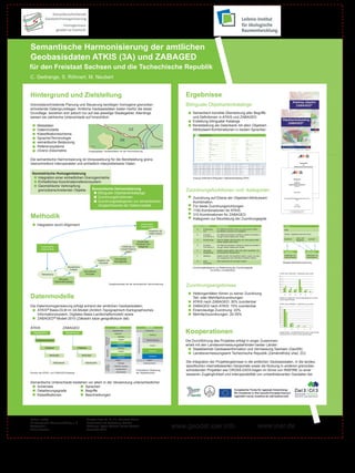
  • 1. Semantische Harmonisierung der amtlichen Geobasisdaten ATKIS (3A) und ZABAGED für den Freistaat Sachsen und die Tschechische Republik C. Gedrange, S. Röhnert, M. Neubert Hintergrund und Zielstellung Ergebnisse Grenzüberschreitende Planung und Steuerung benötigen homogene grenzüber- Bilinguale Objektartenkataloge schreitende Datengrundlagen. Amtliche Geobasisdaten bieten hierfür die beste Grundlage, beziehen sich jedoch nur auf das jeweilige Staatsgebiet. Allerdings Semantisch korrekte Übersetzung aller Begriffe weisen sie zahlreiche Unterschiede auf hinsichtlich: und Definitionen in ATKIS und ZABAGED Erstellung bilingualer Kataloge Metadaten Bereitstellung als Datenbank mit allen Objektart- Datenmodelle CZ Attributwert-Kombinationen in beiden Sprachen Klassifikationsschema Sprache/Terminologie DE semantische Bedeutung Referenzsysteme ATKIS ® ZABAGED ® (Grenz-)Geometrie Ausgangslage: Geobasisdaten vor der Harmonisierung Die semantische Harmonisierung ist Voraussetzung für die Bereitstellung grenz- überschreitend interoperabler und einheitlich interpretierbarer Daten. Geometrische Homogenisierung Integration einer einheitlichen Grenzgeometrie Auszug Datenbank Bilingualer Objektartenkatalog ATKIS Einheitliches Koordinatenreferenzsystem Geometrische Verknüpfung grenzüberschreitender Objekte Semantische Harmonisierung Zuordnungsfunktionen und -kategorien Bilinguale Objektartenkataloge Zuordnungsfunktionen Zuordnung auf Ebene der Objektart-Attributwert- Zuordnungskategorien zur semantischen Kombination Vergleichbarkeit der Datenmodelle Für beide Zuordnungsrichtungen 1100 Kombinationen für ATKIS Methodik 310 Kombinationen für ZABAGED Kategorien zur Beurteilung der Zuordnungsgüte Integration durch Alignment Interoperable Datenmodelle Kategorie Qualität Beschreibung ATKIS A Eineindeutig Ein Objekt aus Modell A lässt sich genau einem Objekt Wald Integration der A=Z aus Modell Z zuordnen und umgekehrt. Datenmodelle B Eindeutig: Ein Objekt des Modells A enthält ein Objekt des Modells Z Attribut: Vegetationsmerkmal (VEG) Z ist Teil von A und ggf. weitere Objekte oder Inhalte. Laub- und Teile der Objekte überschneiden sich, aber jedes enthält Nadelholz Laubholz C Schnittmenge Nadelholz Zuordnungs- weitere Objekte oder Inhalte. funktionen und D Eindeutig: Ein Objekt des Modells Z enthält ein Objekt des Modells A B D D D Ursprüngliche Erstellung von -kategorien A ist Teil von Z und ggf. weitere Objekte oder Inhalte. Datenmodelle Transformations- E Teilmenge, Objekte werden geführt, aber nicht näher spezifiziert. Sie regeln übergeordnet sind semantisch übergeordnet. ZABAGED ZABAGED F Ableitung Objekte werden nicht spezifiziert geführt, lassen sich aber Waldboden mit Waldboden mit aus umgebenden oder enthaltenen Objekten ableiten. Latschenkiefern Baumbestand Homogenität Vergleich der Keine passenden Zuordnungen möglich. Heterogenität G keine Konzepte Zuordnung Beispiel Mehrfachzuordnung Semantische Zuordnungskategorien zur Bestimmung der Zuordnungsgüte Analyse (A=ATKIS, Z=ZABAGED) Semantische Übersetzung Konzepte ATKIS nach ZABAGED ZABAGED nach ATKIS 60 Bilinguale 50 Objektartenkataloge 40 Vorgehensweise bei der semantischen Harmonisierung Zuordnungsergebnisse 30 20 10 Heterogenitäten führen zu keiner Zuordnung, 0 Datenmodelle Teil- oder Mehrfachzuordnungen A B C D E F Anteile der vergebenen Zuordnungskategorien für beide Zuordnungsrichtungen ATKIS nach ZABAGED: 30% zuordenbar ATKIS nach ZABAGED ZABAGED nach ATKIS Die Datenhomogenisierung erfolgt anhand der amtlichen Geobasisdaten: ZABAGED nach ATKIS: 70% zuordenbar 90 ATKIS® Basis-DLM im 3A-Modell (Amtlich Topographisch-Kartographisches Eineindeutige Zuordnung: 20% 80 70 Informationssystem, Digitales Basis-Landschaftsmodell) sowie Mehrfachzuordnungen: 20-35% 60 50 ZABAGED ® Modell 2010 (Základní báze geografických dat) 40 30 20 10 ATKIS ZABAGED ATKIS ZABAGED 0 Kooperationen 1 2 3 4 5 Basisschema Festpunkte Objektbereich Objektbereich Gebäude Anteile Einfach- und Mehrfachzuordnung an zugeordneten Kombinationen für beide Zuordnungsrichtungen Siedlung Siedlung Tatsächliche Tatsächliche Nutzung Nutzung Objektartengruppe Verkehr Vegetation Stromerzeugung Die Durchführung des Projektes erfolgt in enger Zusammen- Gewässer Verkehr arbeit mit den Landesvermessungsbehörden beider Länder: Objektart Objektart Siedlung Staatsbetrieb Geobasisinformation und Vermessung Sachsen (GeoSN) Bauwerke Verkehr Vegetation Attributart Vegetation Landesvermessungsamt Tschechische Republik (Zeměměřický úřad, ZÚ) Attributart Gewässer Gewässer Relief Relief Attributwert Attributwert Kataloge Gebietseinheiten Die Integration der Projektergebnisse in die amtlichen Geobasisdaten, in die landes- spezifischen internetbasierten Geoportale sowie die Nutzung in anderen grenzüber- einheiten Gebiets- Öffentlich-rechtlich Geographisch Administrativ Thematische Gliederung schreitenden Projekten wie CROSS-DATA tragen im Sinne von INSPIRE zu einer Struktur der ATKIS- und ZABAGED-Kataloge der Objektbereiche besseren Zugänglichkeit und Interoperabilität von umweltrelevanten Geodaten bei. Semantische Unterschiede bestehen vor allem in der Verwendung unterschiedlicher Schemata Sprachen Detailierungsgrade Begriffe Klassifikationen Beschreibungen Leibniz-Institut Leibniz Institute Direktor: Prof. Dr. Dr. h.c. Bernhard Müller Director: Prof. Dr. Dr. h.c. Bernhard Müller www.ioer.de für ökologische Raumentwicklung e. V. Posterinhalt und Gestaltung: Claudia www.geodat.ioer.info of Ecological and Regional Development Weberplatz 1 1 Weberplatz 01217 Dresden 01217 Dresden Gedrange, Sylvia Röhnert, Marco Neubert November 2010 www.ioer.de Germany